A Deep Dive on Coer d’Alene History
An Intimate Chronicle of Coeur d’Alene, Idaho
Prologue: A Lake Carved by Time
In the verdant cradle of northern Idaho’s Panhandle, Coeur d’Alene emerges as a living mosaic, where the raw power of ancient ice meets the enduring spirit of human resilience. This chapter does not merely recount dates and events; it unfolds the city’s epic as a vibrant, multi-layered saga—echoing the ancestral songs of the Schitsu’umsh people who once called the lake their sacred heart, the explosive thunder of dynamite in the mining wars, the steady churn of steamboat paddles hauling timber and dreams across its waters, and the soft, rhythmic ripple of gentle waves lapping against the world’s only floating golf green at the modern resort. From the primordial depths sculpted by cataclysmic floods to the sparkling horizons of today’s tourism mecca, we excavate the geological and human strata that have forged Coeur d’Alene into a place where history pulses palpably: in the whisper of towering evergreens, the sapphire gleam of the lake at dawn, and the quiet determination of a community that has repeatedly reinvented itself amid nature’s fury and human ambition.
At the foundation of it all lies the land itself—a dramatic geological theater that long predates any human memory. The story begins during the Pleistocene epoch, roughly 2.5 million to 11,700 years ago, when vast ice sheets dominated the northern hemisphere. In the Pacific Northwest, the Cordilleran Ice Sheet—a colossal mass of ice originating in the mountains of British Columbia—sent a massive lobe, known as the Purcell Trench lobe, surging southward into the Idaho Panhandle. This advancing ice finger, up to 4,000 feet thick in places, blocked the Clark Fork River, impounding enormous volumes of meltwater behind it and creating Glacial Lake Missoula. This prehistoric inland sea stretched across much of western Montana, covering an area comparable to modern Lake Erie and Lake Ontario combined, with depths reaching 2,000 feet and holding over 500 cubic miles of water—equivalent to half the volume of Lake Michigan.
The drama intensified when the ice dam inevitably failed. Periodic ruptures—estimated to have occurred dozens of times (perhaps 40 to 100 or more) between approximately 18,000 and 13,000 years ago—unleashed some of the most powerful floods ever recorded on Earth. These cataclysmic glacial lake outburst floods (GLOFs), often called the Missoula floods or Spokane floods, roared across northern Idaho, eastern Washington, and down the Columbia River Gorge at speeds approaching 60-80 mph, with peak discharges rivaling 10 times the flow of the Amazon River. Walls of water up to 2,000 feet high stripped away soil, boulders, and entire landscapes, carving deep coulees, scablands, and braided channels in the basalt bedrock. In the immediate vicinity of what would become Lake Coeur d’Alene, the floods deposited massive gravel bars and sediments that helped dam tributary valleys, contributing to the lake’s formation as meltwater pooled in the glacially scoured basin left by the retreating ice. The Rathdrum Prairie, just north of the modern city, bears stark evidence of these megafloods: vast expanses of gravelly outwash plains, erratic boulders carried hundreds of miles, and subtle ridges marking successive flood surges.
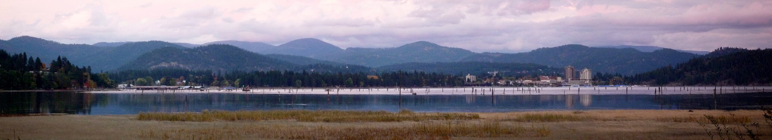
This glacial legacy endowed the region with extraordinary natural gifts: a 25-mile-long, 10-mile-wide lake averaging 100 feet deep (plunging to 220 feet in spots), fed by crystal-clear rivers like the Coeur d’Alene and St. Joe, and surrounded by fertile prairies, dense western white pine forests, and abundant fisheries. Yet it also left scars—unstable sediments, altered drainages, and a landscape profoundly reshaped by repeated cataclysms. These same forces created the groundwater aquifers that sustain the area today and sculpted the dramatic topography that draws millions of visitors.
Woven through this ancient canvas are the threads of human endeavor, beginning with the Schitsu’umsh (the “Found Ones” or “Those Who Were Found Here”), whose stewardship of the land spanned at least 9,000 years in oral tradition and archaeology. Their harmonious existence—centered on seasonal cycles of fishing, gathering camas roots, hunting, and spiritual practices tied to the lake and mountains—was disrupted by European incursions starting in the early 1800s. Fur traders, missionaries, and later settlers brought trade goods, diseases, and conflict, leading to treaties, wars, and reservation boundaries that confined but did not extinguish their legacy.
The 19th century brought industrial clamor: silver and gold strikes in the Coeur d’Alene Mountains ignited violent mining booms and labor strife, while vast white pine forests fueled a timber empire that peaked in the 1920s before crashing in the Great Depression. Resilience defined the 20th century—New Deal projects, World War II naval training at nearby Farragut, and post-war shifts toward recreation. By the 1980s, the city had transformed into a tourism renaissance, anchored by the luxurious Coeur d’Alene Resort and its iconic floating green, Silverwood Theme Park, pristine trails, and world-class outdoor pursuits.
Each era reveals not just events, but the souls who shaped them: shrewd Schitsu’umsh traders whose “hearts like the point of an awl” earned them their French-given name; fur trader David Thompson mapping uncharted waters; Jesuit missionaries building Idaho’s oldest structure; miners risking life in the Silver Valley; lumber barons harnessing rivers; and modern visionaries like Duane Hagadone turning a motor inn into a lakeside icon. This is the story of a place where nature’s cataclysmic fury and human ambition have intertwined for millennia, creating a legacy that endures in the lake’s profound depths and the city’s vibrant spirit—a testament to adaptation, beauty, and the quiet power of place.
Prologue: A Lake Carved by Time
In the verdant cradle of northern Idaho’s Panhandle, Coeur d’Alene emerges as a living mosaic, where the raw power of ancient ice collides with the enduring spirit of human resilience and reinvention. This chapter does not merely list dates and events in dry succession; it unfolds the city’s epic as a vibrant, multi-layered saga—resonating with the ancestral songs and oral traditions of the Schitsu’umsh people, who once regarded the lake as their sacred heart and center of existence; the explosive thunder of dynamite during the violent mining wars of the 1890s; the steady, rhythmic churn of massive steamboat paddles hauling timber, ore, and frontier dreams across its shimmering surface; and the soft, almost meditative ripple of gentle waves lapping against the world’s only floating, movable golf green at the iconic Coeur d’Alene Resort. From the primordial depths gouged and flooded by cataclysmic Ice Age forces to the sparkling, sun-dappled horizons of today’s thriving tourism mecca, we excavate the intertwined geological and human strata that have forged Coeur d’Alene into a place where history pulses palpably: in the whisper of towering western white pines swaying in the breeze, the sapphire gleam of the lake at first light, and the quiet, determined spirit of a community that has repeatedly adapted and reinvented itself amid nature’s overwhelming fury and humanity’s unyielding ambition.
At the very foundation of it all lies the land itself—a dramatic geological theater whose drama long predates any trace of human memory or presence. The story opens deep in the Pleistocene epoch, roughly 2.6 million to 11,700 years ago, when vast continental ice sheets dominated much of the Northern Hemisphere during repeated glacial advances and retreats. In the Pacific Northwest, the Cordilleran Ice Sheet—a massive, continent-spanning blanket of ice originating in the high mountains of British Columbia—extended a formidable southern arm known as the Purcell Trench lobe. This advancing ice finger, in places up to 4,000 feet thick and more than 40 miles wide, pushed southward into the Idaho Panhandle, overriding valleys and blocking the natural drainage of the Clark Fork River. Behind this colossal ice dam, meltwater accumulated to form Glacial Lake Missoula, an immense prehistoric inland sea that at its maximum covered roughly 3,000 square miles across western Montana. The lake reached depths of up to 2,000 feet near the dam, held an estimated 500–2,600 cubic miles of water (a volume comparable to half of modern Lake Michigan or the combined capacity of Lakes Erie and Ontario), and backed up into tributary valleys for hundreds of miles.
The true cataclysm unfolded each time the ice dam failed under the mounting hydrostatic pressure. Periodic ruptures—now estimated by geologists to have occurred dozens to possibly over 100 times, with refined recent studies (including 2024 research on exposure dating and stratigraphic records) concentrating the most intense activity between approximately 18,000–17,000 and 13,000–14,000 years ago—unleashed some of the most powerful freshwater floods ever documented on Earth. These glacial lake outburst floods (GLOFs), widely known as the Missoula floods (or Spokane floods), surged across northern Idaho, eastern Washington, and down the Columbia River Gorge in terrifying walls of water reaching heights of 1,000–2,000 feet in constricted channels. Peak discharges have been modeled as high as 17 cubic kilometers per hour (equivalent to 10–17 times the flow of the Amazon River), with velocities approaching 60–80 mph (up to 130 km/h in some estimates). These megafloods stripped away soil, loess, and entire layers of basalt bedrock; transported house-sized erratic boulders hundreds of miles from their source; carved deep coulees, giant current ripples, and the iconic Channeled Scablands; and deposited vast gravel bars, braided channels, and slackwater sediments in backwater areas.
In the immediate region that would become Lake Coeur d’Alene and the surrounding area, the floods played a crucial role in lake formation. As the Purcell lobe retreated northward near the end of the last glacial maximum, it left behind a glacially scoured basin. Successive Missoula floods roared through, eroding and depositing enormous volumes of sediment—filling side valleys, damming tributaries, and allowing meltwater to pond in the deepened depression. The Rathdrum Prairie, immediately north of modern Coeur d’Alene, stands as stark testament to this violence: vast gravelly outwash plains, fields of erratic boulders (some weighing thousands of tons and transported far from their origins), subtle streamlined ridges marking successive flood surges, and deeply notched cliffs where water scoured the landscape. These same processes contributed to the lake’s current configuration—a 25-mile-long, up to 10-mile-wide body of water averaging 100 feet deep, plunging to 220 feet in places, fed by the clear-flowing Coeur d’Alene and St. Joe Rivers, and draining westward via the Spokane River toward the Columbia and Pacific.
This glacial inheritance bestowed extraordinary natural gifts: fertile prairies ideal for camas meadows, dense stands of western white pine that would later fuel an industrial empire, and one of the cleanest, most scenic large lakes in the inland Northwest, teeming historically with salmon, trout, and whitefish. Yet it also left enduring scars—unstable glacial sediments prone to landslides, altered river courses, and a hydrogeology shaped by flood-deposited aquifers that now supply drinking water to hundreds of thousands. These features continue to influence modern life, from groundwater recharge to the dramatic topography that draws hikers, boaters, and golfers.
Threaded through this ancient, violent canvas are the persistent strands of human endeavor. The Schitsu’umsh (“Those Who Were Found Here”) arrived in deep time—oral traditions and archaeology point to at least 9,000 years of continuous presence, though their stories speak of “time immemorial.” Their worldview, rich with tales of Coyote the trickster (who released the salmon and shaped landscapes) and Crane (who taught sharing and generosity), emphasized harmony with the land, seasonal cycles of fishing, root gathering, hunting, and suumesh spiritual practices tied intimately to the lake and mountains. European contact in the early 1800s—first through fur traders, then missionaries—brought trade goods, devastating epidemics, treaties, and conflict that confined but could not erase their legacy.
The 19th century ushered in industrial clamor: rich silver and lead strikes in the nearby Coeur d’Alene Mountains sparked booms and brutal labor conflicts in the 1890s, while the region’s vast white pine forests powered a timber empire that peaked in the 1920s before collapsing amid the Great Depression. The 20th century tested resilience through New Deal infrastructure projects, the massive World War II naval training station at nearby Farragut on Lake Pend Oreille, and a gradual postwar pivot toward recreation and leisure. By the 1980s, Coeur d’Alene had blossomed into a full tourism renaissance, anchored by the luxurious Coeur d’Alene Resort (opened 1986) with its revolutionary floating island green, Silverwood Theme Park (1988), extensive trail systems like Tubbs Hill, and world-class outdoor pursuits that now define the area’s economy and identity.
Across every era, it is the souls who shaped this place that bring the story alive: the shrewd Schitsu’umsh traders whose bargaining prowess earned them the French moniker “Coeur d’Alene” (“heart of the awl”); explorer David Thompson meticulously charting unknown waters in 1807–1809; Jesuit Father Pierre-Jean De Smet founding the Sacred Heart Mission in 1842; hard-bitten miners risking everything in the Silver Valley; lumber barons who harnessed rivers and railroads; and modern entrepreneurs like Duane Hagadone, who transformed a modest motor inn into a lakeside icon. This is the enduring narrative of Coeur d’Alene: a place where nature’s cataclysmic fury and human ambition have intertwined across millennia, forging a legacy that lives on in the lake’s profound depths, the city’s vibrant spirit, and the quiet power of a landscape that continues to inspire adaptation, beauty, and wonder.
The Schitsu’umsh: Guardians of the Land
For millennia—archaeological evidence and oral traditions suggest at least 9,000 years, though the tribe’s presence extends to “time immemorial”—the Schitsu’umsh, meaning “Those Who Were Found Here” or “The Discovered People,” have been the steadfast guardians of a vast homeland spanning nearly 5 million acres. This territory stretched from the southern shores of Lake Pend Oreille in the north, along the Bitterroot Range of Montana in the east, southward to the Palouse and North Fork of the Clearwater River, and westward to Steptoe Butte and just east of Spokane Falls. At its heart lay Lake Coeur d’Alene, a sacred body of water fed by the Coeur d’Alene, St. Joe, Clark Fork, and Spokane Rivers, surrounded by grass-covered hills, camas prairies, forested mountains, marshes, and abundant fisheries.
Unlike the nomadic Plains tribes, the Schitsu’umsh established numerous permanent villages along these rivers and lake shores, including sites at Hayden Lake and Lake Pend Oreille. Each village held a distinct name in the ancestral language, Snchitsu’umshtsn (an Interior Salishan tongue), reflecting its unique identity and role in the community. One prominent ancient headquarters and village site was known as Hnch’mqinkwe’ (translated as “place-surface-head-water”), located at the confluence of the Spokane and Coeur d’Alene Rivers—now the modern city of Coeur d’Alene, Idaho. These villages served as hubs for fishing, gathering, intertribal trade, and social life, fostering close relationships with neighbors like the Spokane to the west, Kootenai and Kalispel to the north, Nez Perce to the south, and Flathead (Kootenai-Salish) to the east. Ancient trade routes connected them to distant groups, including the Shoshone, Bannock, and even Plains peoples.
As Interior Salish speakers, the Schitsu’umsh lived in harmony with seasonal rhythms. They resided in permanent cone-shaped or mat-covered lodges (often earth or bark structures, not the semi-subterranean pit houses common elsewhere in the Plateau), clustered near resource-rich sites. Spring brought the gathering of roots like camas (a staple lily bulb roasted in earth ovens), bitterroot, and cous in open prairies, alongside fishing for cutthroat trout and whitefish in local streams. Summer focused on berry collection—chokecherries, huckleberries, serviceberries—and vision quests for spiritual guardians known as suumesh. Fall and winter emphasized salmon runs (traded from Columbia River sites like Celilo Falls), hunting deer, elk, moose, bear, and small game, with communal drives herding animals to water crossings for archery kills using short, recurved sinew-backed bows. Meat was shared equitably, especially with the vulnerable. After acquiring horses around the 1760s (via trade from southern tribes), mobility exploded: young men journeyed east to hunt bison on the Plains, adopting tepees for those trips while maintaining lake-based villages year-round.
Their cosmology centered on the Animal Peoples, or First Peoples, who shaped the world before humans. Coyote, the trickster, and Crane were central figures in oral traditions told during long winter nights by elders. In one key story, Coyote entered a monster’s stomach to free the Animal Peoples, then killed it; from its parts, various Human Peoples—including the Schitsu’umsh—were created and placed on their lands. Crane taught sharing and generosity (e.g., providing venison to starving villagers), while Coyote released Salmon and other Fish Peoples trapped at Celilo Falls. These teachings instilled reverence for natural law, environmental stewardship, and communal harmony. Spiritual practices included shamanism, elaborate ceremonies emphasizing social equality, and suumesh songs and dances—performed before hunts, in sweat houses, or during Winter Medicine Dances—to seek spiritual assistance, bring good luck for gathering and hunting, and maintain health and prosperity. Neglecting these could lead to illness or misfortune.
Pre-contact population estimates hovered around 5,000, sustained by the land’s abundance: trout, salmon, whitefish, water potatoes, deer, elk, and berries. But European contact—indirect at first through trade networks—brought devastation. Smallpox and other epidemics (likely from coastal routes) struck hard, with major outbreaks in 1831, 1847, and 1850 reducing numbers to about 500 by mid-century—an 80-90% decline that eroded expertise, collective wisdom, and resilience against raids.
French traders in the late 18th/early 19th century dubbed them “Coeur d’Alene” (“Heart of the Awl”) for their sharp, disciplined bargaining—truly “pointed hearts.” Despite this devastation, cultural resilience endured through oral traditions, language, and adaptation. Today, the federally recognized Coeur d’Alene Tribe maintains sovereignty over a 345,000-acre reservation (established 1873 by Executive Order, expanded/reduced later), primarily in Kootenai and Benewah counties, with over 2,190 enrolled members. Enterprises like the Coeur d’Alene Casino Resort Hotel (opened 1993, employing ~500, generating ~$20 million annually), Circling Raven Golf Club, tribal farm (6,000 acres producing wheat, barley, peas, lentils, canola), Benewah Market, and others blend tradition with modern economies.
Language revitalization thrives through classes in Snchitsu’umshtsn (taught at the tribal school since 1997), cultural centers, and youth programs. Ongoing stewardship includes landmark environmental lawsuits: 1991 against mining companies for toxic waste damages (leading to the Coeur d’Alene Basin Restoration Project, one of America’s largest environmental justice efforts), with settlements in 2008 (ASARCO $452 million) and 2011 (Hecla $263.4 million) funding cleanup and habitat restoration. The tribe asserts jurisdiction over the lower third of Lake Coeur d’Alene (upheld by Supreme Court in 2001), setting its own water-quality standards and restoring fish habitats amid Superfund challenges. This echoes their ancient role as guardians, ensuring the land’s health for future generations while honoring the teachings of Coyote, Crane, and the Animal Peoples.
Whispers from the West: European Exploration and Fur Trade
The first faint echoes of European presence in the Coeur d’Alene region arrived not with fanfare but with the tentative footsteps of explorers navigating an uncharted wilderness. In the fall of 1805, the Lewis and Clark Expedition—commissioned by President Thomas Jefferson to chart a path to the Pacific—skirted the fringes of Schitsu’umsh territory. Traveling along the Clearwater River and into the Snake River basin, they did not venture directly into the heart of Lake Coeur d’Alene but passed nearby, documenting conical lodges along the waterways and encountering Plateau tribes. On their return journey in the spring of 1806, specifically on May 6, Captains Meriwether Lewis and William Clark met three Coeur d’Alene men at the mouth of the Potlatch River, which they dubbed Colter’s Creek after Private John Colter. The encounter was brief but cordial; the Coeur d’Alene shared salmon and roots, while Clark provided medical aid for eye ailments common among the tribes due to smoke-filled lodges. Lewis noted their distinctive conical mat lodges and canoes, but the expedition pressed onward, focused on survival amid the rugged Bitterroot Mountains. This fleeting contact marked the initial brush with American exploration, introducing the region to the broader ambitions of Manifest Destiny, though the Corps of Discovery’s journals offered only glimpses of the Schitsu’umsh world.
True European intrusion deepened with the arrival of British fur trader David Thompson in 1807-1809, a pivotal figure whose meticulous surveys and trading posts forever altered the Northwest. Born in London in 1770 to Welsh parents, Thompson apprenticed with the Hudson’s Bay Company at age 14, honing skills in surveying, astronomy, and cartography. By 1797, he defected to the rival North West Company, driven by a passion for exploration. In 1807, tasked with expanding trade across the Rockies, Thompson crossed Howse Pass into the Columbia River basin, establishing Kootenae House near present-day Invermere, British Columbia—the first European post west of the Rockies. Pushing southward, he explored the Kootenai River through Idaho and Montana, wintering with the Salish and Kootenai tribes. In September 1809, accompanied by Finan McDonald, a French-Canadian voyageur, and French-speaking Iroquois scouts, Thompson descended the Pend Oreille River from Lake Pend Oreille in northern Idaho. From September 27 to October 6, they scouted downstream through what is now Pend Oreille County, Washington, becoming the first non-Indigenous people in the area. On the lake’s north shore, near modern Hope, Idaho, Thompson erected Kullyspell House (a misspelling of “Kalispel,” a Salish tribe)—Idaho’s inaugural trading post. Built from local timber, it served as a hub for bartering beaver pelts, muskrat, and other furs with the Schitsu’umsh and neighboring tribes.
The name “Coeur d’Alene” itself emerged from these interactions. Thompson’s Iroquois guides, fluent in French from earlier fur trade ties, described the Schitsu’umsh’s shrewd bargaining as hearts “pointed like an awl” (“coeur” for heart, “alêne” for awl), a moniker that stuck for the tribe, lake, and river. Thompson continued his ventures, founding Saleesh House near Thompson Falls, Montana, in 1809, and Spokane House in Washington, creating a network of posts that mapped over 50,000 miles and surveyed nearly two million square miles. His journals, rich with astronomical observations, detailed the region’s rivers, mountains, and indigenous lifeways, positioning the North West Company to dominate the fur trade.\
Trade brought profound changes to the Schitsu’umsh. European goods—guns, metal tools, kettles, blankets, and beads—enhanced hunting, cooking, and daily life, integrating into existing networks where the Coeur d’Alene exchanged venison and hides for salmon at communal gatherings. Horses, acquired around 1760, amplified mobility, but trade also introduced alcohol, fostering dependency and social discord. Most devastating were the epidemics: Indirect contact via trade routes unleashed smallpox in 1825 and deadly fevers from 1829-1832, decimating populations already strained by earlier outbreaks. A Coeur d’Alene tradition, recorded later by missionaries, linked smallpox to a spotted calico shirt from a trader, symbolizing the perceived supernatural threat of these “gifts.” The fur trade, while economically beneficial, eroded traditional skills—why craft stone tools when metal ones were available?—and heightened intertribal competition for pelts, leading to overhunting and resource depletion.
By the 1820s, following the 1821 merger of the North West Company with the Hudson’s Bay Company, British dominance solidified. Under Chief Factor John McLoughlin at Fort Vancouver, the HBC monopolized the Plateau fur trade, blending European commerce with indigenous practices but exacerbating overhunting and cultural shifts. Thompson retired in 1812, but his routes facilitated this expansion, integrating the region into global markets driven by European demand for beaver hats.
The 1846 Oregon Treaty marked a turning point, ceding the region south of the 49th parallel to the United States and ending joint occupancy established in 1818. This resolved escalating tensions—fueled by American slogans like “Fifty-Four Forty or Fight!”—but shifted control, diminishing British fur trade influence as American settlers flooded in. The treaty preserved HBC navigation rights on the Columbia but signaled the decline of the old fur era, paving the way for missionaries, military posts, and irreversible change for the Schitsu’umsh.
This era of whispers from the west sowed seeds of transformation, as fur posts like Kullyspell House bridged worlds, introducing commerce that enriched yet eroded indigenous lifeways, setting the stage for the missionary interlude and the inexorable tide of settlement.
Missionary Era and Early Conflicts (1840s-1850s)
The 1840s marked a pivotal turning point for the Schitsu’umsh (Coeur d’Alene) people, as centuries-old oral prophecies converged with the arrival of Jesuit missionaries, ushering in an era of profound cultural exchange, religious transformation, and mounting tension with encroaching American authority. Central to this story is a longstanding tribal prophecy attributed to Chief Circling Raven (around 1740), who dreamed of “men in black robes” (the Jesuits) who would bring spiritual teachings from a “Great Chief who dwells in the Sky.” This vision, passed down through generations, described these figures as bearers of a new way of life, complete with “crossed sticks” (crucifixes) and guidance that would benefit the people. The prophecy gained urgency in the early 19th century as indirect reports of Christian teachings reached the Plateau tribes, often via Iroquois trappers or Flathead intermediaries who had encountered Jesuits or Protestant missionaries. By the 1830s, delegations from several tribes—including Nez Perce and Flathead—traveled to St. Louis seeking these “Blackrobes,” fueling Jesuit interest in the region.
Father Pierre-Jean De Smet, a Belgian-born Jesuit known as the “Apostle of the Rockies,” became the fulfillment of this prophecy. De Smet, who had emigrated to America in 1821 and joined the Society of Jesus, arrived in the Pacific Northwest in 1839-1840 after extensive missionary work among Midwestern tribes. In 1840, he celebrated Mass among Idaho Indians, and by 1841, he established St. Mary’s Mission among the Flathead in Montana’s Bitterroot Valley—the first Catholic mission in the Rockies. Word of the “Blackrobes” spread rapidly. In 1842, responding to urgent invitations from Coeur d’Alene leaders who had heard of his work, De Smet traveled to the northern shore of Lake Coeur d’Alene (near modern Post Falls). There, he baptized 24 adults and many children during his first encounter, describing the people as highly receptive. He left shortly after but sent Father Nicholas Point and Brother Charles Huet to winter with the tribe and establish a permanent presence.
The initial Mission of the Sacred Heart was founded that year on the St. Joe River near its mouth at the lake’s southern end. Point and the Coeur d’Alene built a simple bark chapel and log structures, introducing basic Catholic teachings, prayers, and rudimentary agriculture. However, recurrent spring flooding on the low-lying river plain forced relocation in 1846. Father Joseph Joset selected a new site on a prominent hill overlooking the Coeur d’Alene River near modern Cataldo—about 25 miles east of the lake. A temporary bark chapel was erected, and construction of the permanent church began around 1850 under Father Antonio Ravalli, an Italian Jesuit skilled in medicine, architecture, and art.
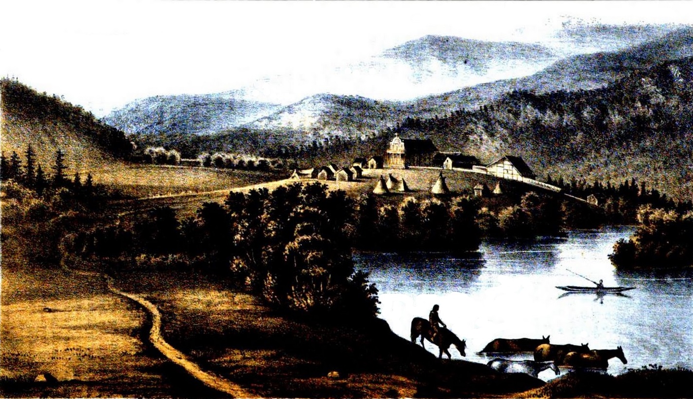
Ravalli, assisted by Brother Huybrechts and a large workforce of Coeur d’Alene men, completed the Mission of the Sacred Heart by 1853 using only local materials and primitive tools: broad-axe, auger, rope, pulleys, penknife, and improvised whipsaw. No nails were used; massive squared timbers (18-22 inches thick, up to 24 feet long) were mortised, tenoned, and wooden-pegged. Walls were built with wattle-and-daub: willow saplings interlaced between uprights, woven with wild grass, and plastered with mud (adobe visible in some interior sections today). The church’s design blended Greco-Roman and Baroque influences—Greek Revival portico with modified Tuscan columns, triglyphs, a pediment with wooden urns and cross, and an Italinate sunburst around a bull’s-eye window. Interior decorations imitated European churches using natural and improvised materials: huckleberry juice for red paint, berries for other colors, tin cans hammered into decorative patterns, and patterned fabric. The result was a 91-foot-long, 40-foot-wide structure rising 52 feet, with thick rock foundation and clapboard exterior added later (1865). It remains Idaho’s oldest standing building and the oldest surviving mission church in the Pacific Northwest.
The mission introduced Catholicism, European-style farming (wheat, oats, potatoes, peas), education (reading, writing, catechism), and medical care (Ravalli treated illnesses). Many Coeur d’Alene converted, blending new practices with traditional ones, though the Jesuits actively suppressed suumesh dances and shamanism as incompatible with Christianity. The mission became a center for community life, agriculture, and trade, with Coeur d’Alene labor sustaining it until 1877. Father De Smet visited frequently, praising the people’s devotion.
Yet this era of apparent harmony masked growing external pressures. The Oregon Treaty of 1846 ceded the region south of the 49th parallel to the U.S., accelerating American settlement and territorial ambitions. In the 1850s, Washington Territory Governor Isaac Stevens aggressively pursued treaties to clear land for settlers, railroads, and resources. Stevens negotiated multiple treaties in 1855 (e.g., Yakama, Nez Perce, Flathead), often under duress, promising reservations while opening vast areas to non-Native use. The Coeur d’Alene were not included in the main 1855 councils (Walla Walla, Hell Gate), but Stevens pressured them separately. Tensions escalated as settlers encroached, ignoring tribal lands.
This culminated in the Coeur d’Alene War of 1858 (also called the Spokane or Plateau War). In May, Lieutenant Colonel Edward Steptoe led 164 troops from Fort Walla Walla north toward Colville to investigate miner-Indian disputes and assert authority. Near modern Steptoe Butte (Tohotonimme), allied Yakama, Palouse, Spokane, and Coeur d’Alene warriors—numbering around 1,000—attacked on May 17. Outnumbered and outmaneuvered, Steptoe’s force suffered heavy losses (five killed, many wounded) before retreating under cover of darkness. Father Joset intervened to prevent further bloodshed.
Retribution came swiftly. In August-September, Colonel George Wright led 700 well-armed troops (including dragoons, artillery with new rifles, and Nez Perce scouts) from Fort Walla Walla. On September 1 at Four Lakes (near Spokane), Wright decisively defeated allied forces. On September 5 at Spokane Plains, another rout ensued. Wright’s campaign was brutal: troops destroyed food caches, slaughtered 800-900 horses (to cripple mobility), burned villages, and executed several leaders. One site became “Hangman Creek” after hangings (including Chief Qualchan). The Coeur d’Alene sued for peace, leading to informal agreements but no formal treaty until later.
The mission era thus blended spiritual convergence with cultural suppression and foreshadowed dispossession. The Cataldo site, abandoned after 1877 (when the mission moved to DeSmet on the new reservation), became Old Mission State Park in 1975, preserving the church as a National Historic Landmark and symbol of complex intercultural history.
Military Establishment and Settlement (1870s-1880s)
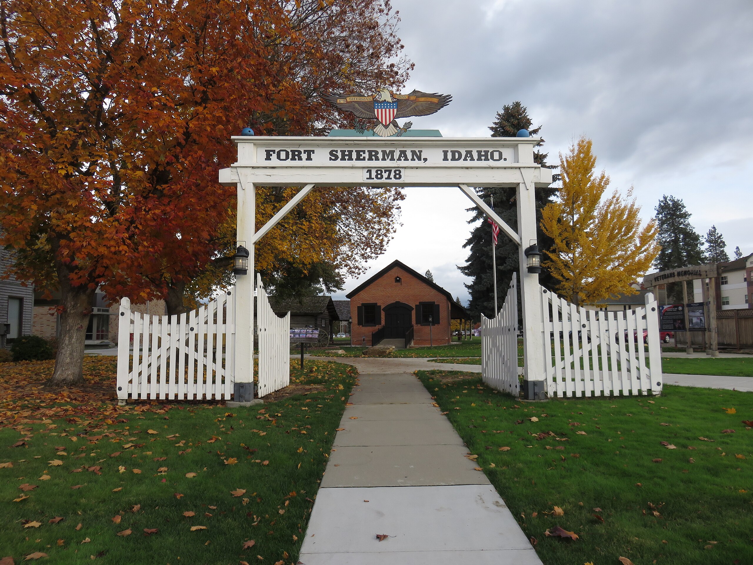
The 1870s and 1880s marked a transformative era for the Coeur d’Alene region, as lingering tensions from the Indian Wars intersected with accelerating mineral discoveries, military presence, and infrastructure development that propelled the area from isolated frontier to bustling settlement hub. Gold finds in the 1860s along the north fork of the Coeur d’Alene River had already drawn prospectors, but the watershed moment came in June 1876 with Custer’s defeat at Little Bighorn, igniting widespread fears of renewed Native uprisings across the West. In 1877, General William Tecumseh Sherman—the famed Civil War commander—toured the region en route from Montana to the Pacific Northwest via the newly completed Mullan Road (built 1859-1862 as the first wagon road across the Rockies into the inland Northwest). Observing the strategic value of Lake Coeur d’Alene’s north shore—at the outflow of the Spokane River—and concerned about potential threats to settlers, railroad surveyors, and telegraph lines, Sherman recommended establishing a military post there to maintain peace, protect communications, and monitor the Canadian border.
Construction began promptly in 1878 under Captain Richard Comba and the 1st Cavalry. Initially designated Camp Coeur d’Alene on April 16, 1878, the post was upgraded to Fort Coeur d’Alene in 1879. Troops and equipment relocated from Spokane Falls, and buildings rose rapidly: barracks, officers’ quarters, a hospital, storehouses, stables, and a powder magazine—all framed in local timber with scenic views overlooking the lake. The fort spanned nearly 1,000 acres, praised for its beauty (often called one of the most picturesque in the Army) yet criticized by some soldiers for isolation and harsh winters. In 1887, upon Sherman’s retirement, it was renamed Fort Sherman in his honor.
The military presence catalyzed civilian settlement. A small village sprouted just east of the fort’s boundaries, initially serving soldiers, suppliers, and transients. Entrepreneurs established stores, saloons, and services catering to troops and travelers along the Mullan Road. By the early 1880s, this hamlet—informally called “Coeur d’Alene”—began taking shape as a permanent community.
The real boom ignited in the 1880s with major silver and lead discoveries in the Coeur d’Alene Mountains (soon dubbed the Silver Valley). Prospectors like A.J. Pritchard struck rich veins in 1883-1884, shifting focus from placer gold to hard-rock mining. Mines like the Bunker Hill and Sullivan poured out ore, drawing thousands of miners, investors, and speculators. Transportation became critical: ore needed hauling from remote canyons to markets.
Enter the railroads and steamboats. In 1880, the fort’s commander commissioned Norwegian immigrant Peter Sorensen—a skilled shipwright who had arrived with a planer from his homeland—to build the lake’s first steamboat. Using fort tools and local materials, Sorensen constructed the 85-foot sternwheeler Amelia Wheaton, named after the post commander’s daughter (Amelia, born 1867). Launched in late 1880 after delays in sourcing parts, it cost about $8,000 and achieved speeds of 8-10 mph, primarily hauling military supplies but soon serving civilians. Sorensen captained it, mapping bays and landmarks still used today.
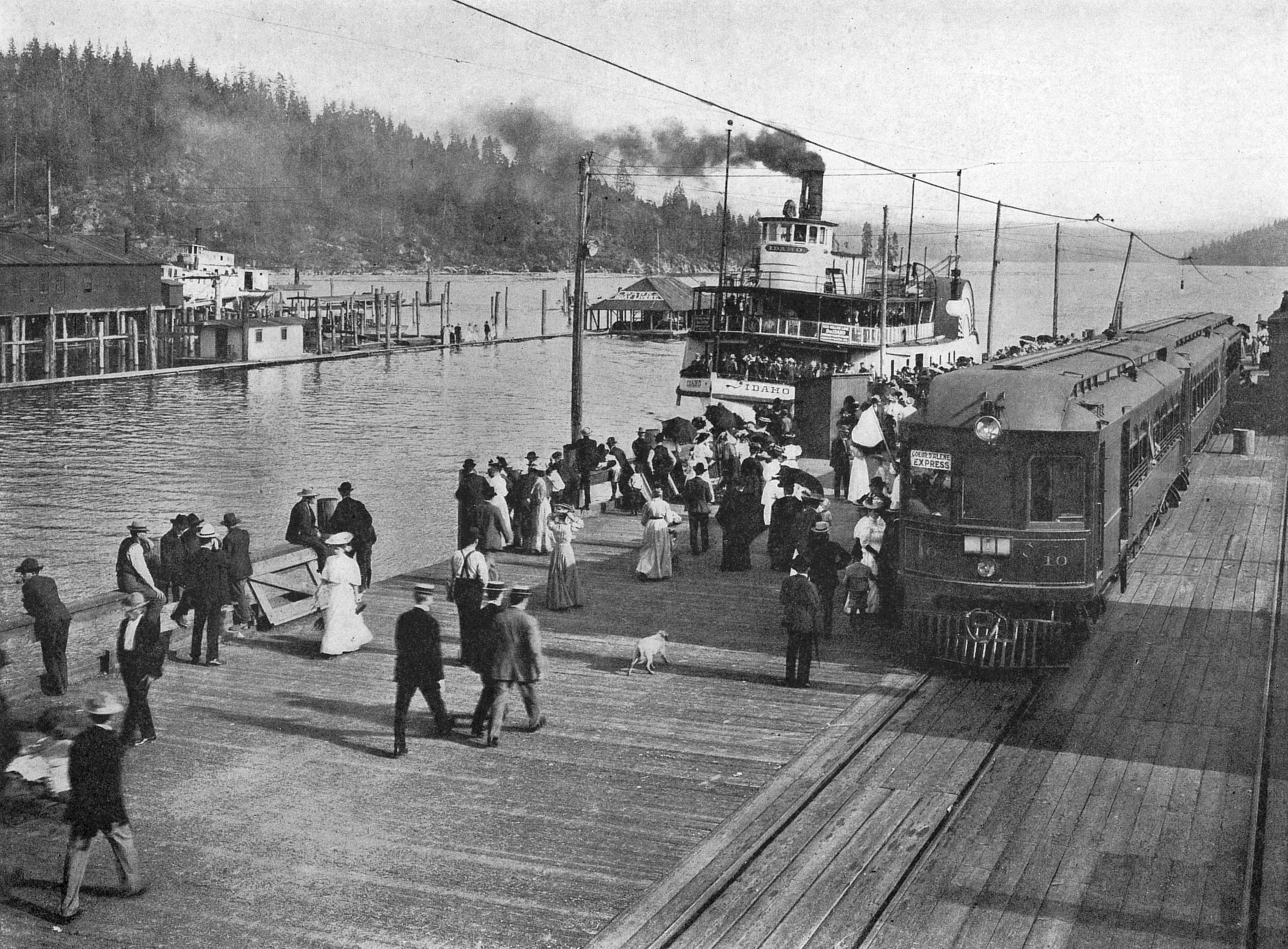
Steamboats proliferated rapidly. Entrepreneur D.C. Corbin built narrow-gauge lines from mines to lake landings (e.g., at Harrison or Mission Landing near Cataldo), where ore transferred to vessels for shipment downlake to Coeur d’Alene city. The Northern Pacific Railroad’s transcontinental mainline reached the region in the early 1880s, with branches pushing closer. By 1886-1888, affiliates like the Coeur d’Alene Railway & Navigation Company connected to lake ports, and Northern Pacific interests acquired steamboat lines. The village became a vital transfer point: ore arrived by boat, loaded onto railcars for smelters westward.
This synergy exploded activity. Steamboats like the Georgie Oakes, Coeur d’Alene, Kootenai, and massive Idaho (carrying 1,000 passengers) plied the lake. By 1910, over 50 operated—more than any western waterway west of the Great Lakes—hauling ore, logs, passengers, mail, and supplies. The lake teemed with traffic, fostering tourism alongside commerce.
The village incorporated as the Town of Coeur d’Alene in 1887 with roughly 40-500 residents (census varying), evolving into a lively frontier outpost with stores, hotels, and saloons. Early photos show wooden storefronts along dusty streets near the waterfront.
Fort Sherman persisted until post-Spanish-American War reductions. Ordered abandoned in March 1900 (vacated September), it closed officially around 1900-1901. Buildings deteriorated under private ownership until the site became North Idaho College in the 1930s. Three originals survive: the chapel (oldest church/school/library), powder magazine, and an officer’s quarters—preserved amid campus grounds, with the iconic gate marking its legacy.
This decade laid Coeur d’Alene’s modern foundations: military security enabled settlement, mining drove economy, and integrated rail-steamboat networks connected it to the world—setting the stage for explosive growth and the labor conflicts ahead.
Mining Booms and Labor Strife (1890s)
The 1890s transformed the Coeur d’Alene Mining District—centered in Idaho’s Silver Valley—from a frontier boomtown into a battleground of class warfare, where the glittering promise of silver and lead clashed violently with the brutal realities of industrial labor. Mining had exploded after major discoveries in the early 1880s: the Bunker Hill lode (struck 1885 by Noah Kellogg’s jackass legend), Sullivan Mine (1884), and others that made the district one of America’s richest for silver, lead, and zinc. By the decade’s start, the region produced millions in ore annually, drawing thousands of hard-rock miners—mostly immigrants from Ireland, Italy, Cornwall, and Eastern Europe—who toiled in dark, dangerous tunnels for wages that fluctuated with metal prices.
Conditions were grim: 10-12 hour shifts underground, constant risk of cave-ins, explosions from faulty powder, silicosis (“miner’s consumption”), and toxic dust from lead-zinc ores. Wages hovered around $3.50 per day for skilled miners in union shops, but non-union operations like Bunker Hill & Sullivan paid less ($3.00 or lower) to undercut organized labor. The Western Federation of Miners (WFM), formed in 1893 partly in response to these conflicts, pushed for uniform wages, safer conditions, and union recognition, but owners resisted fiercely, hiring Pinkerton and Thiel detectives to infiltrate unions and spy on organizers.
The first major eruption came in 1892. On January 16, amid falling silver/lead prices and rising freight costs, mine owners shut down operations and announced wage cuts upon reopening. Miners refused, striking in April. Owners imported non-union “scabs” and armed guards. Tensions boiled over July 11 at the Frisco Mine in Gem: union miners discovered Pinkerton spy Charlie Siringo (posing as a miner) feeding information to owners. A gunfight erupted; strikers dynamited a mill, killing several strikebreakers and guards. Violence spread to Bunker Hill & Sullivan in Wardner: about 500 strikers seized a train, overpowered guards, and blew up the concentrator with a ton of dynamite. Six died in clashes across the district.
Governor N.B. Willey declared martial law July 14. Federal troops arrived, occupying the area for months. Over 600 miners were arrested and confined in makeshift “bullpens”—barbed-wire stockades at Wardner and Wallace where men endured harsh conditions, beatings, and indefinite detention without trial. Many were blacklisted; the union was crushed temporarily. The episode radicalized survivors, birthing the militant WFM.
Labor peace was fleeting. By 1899, the WFM targeted non-union Bunker Hill & Sullivan, which paid lower wages and refused union demands. On April 29, frustrated miners hijacked a Northern Pacific train in Burke—the “Dynamite Express”—loading it with 3,000 pounds of explosives (80 boxes, 50 pounds each). They seized the Wardner mill, routed guards (killing at least one), and detonated the massive concentrator, destroying the world’s largest such facility, company offices, and an Army rifle cache. Two miners died; homes and outbuildings burned in the chaos.
Governor Frank Steunenberg declared martial law again. General Henry C. Merriam led troops to occupy the district, arresting hundreds (including union leaders). Miners faced mass trials, blacklisting, and exile. The crackdown solidified anti-union sentiment among owners and state officials.
The conflicts’ shadow extended to 1905: on December 30, ex-Governor Steunenberg—blamed by radicals for his role in suppressing the strikes—was killed by a bomb at his Caldwell home gate. Harry Orchard (real name Albert Horsley), a former miner and confessed bomber, turned state’s evidence, claiming he acted on orders from WFM leaders William “Big Bill” Haywood (secretary-treasurer), Charles Moyer (president), and George Pettibone. Pinkerton detective James McParland orchestrated the arrests; Haywood, extradited from Colorado in a controversial nighttime kidnapping, faced trial in Boise in 1907.
The “Trial of the Century” pitted Clarence Darrow—legendary defender of labor—for Haywood against prosecutors William Borah (future senator) and James Hawley. Orchard testified dramatically as a serial killer admitting 18-20 murders for hire, but Darrow’s cross-examination exposed inconsistencies and painted him as unreliable. After five months, the jury acquitted Haywood (July 28, 1907); Pettibone was later acquitted, Moyer released. The trial highlighted deep divisions: labor saw it as employer conspiracy; owners viewed unions as terrorist threats.
Environmental fallout compounded the strife. From the 1880s, mills dumped tailings directly into the South Fork Coeur d’Alene River and tributaries—over 60 million tons by 1968, plus 100+ million tons of waste rock containing 2.4 billion pounds of lead. Smelters spewed airborne metals; 1973 Bunker Hill baghouse fire released massive lead (35 tons/month), poisoning children and wildlife. The Coeur d’Alene Basin became one of America’s most contaminated sites. EPA listed the Bunker Hill Mining & Metallurgical Complex as a Superfund site in 1983 (second-largest in U.S.), spanning 1,500 square miles across Idaho and Washington. Cleanup—ongoing—includes river dredging, soil remediation, habitat restoration, and water treatment; settlements (e.g., ASARCO 2008, Hecla 2011) funded billions in efforts, though legacy contamination persists in Lake Coeur d’Alene sediments and floodplains.
The 1890s strife forged American labor history: WFM’s militancy influenced the IWW (“Wobblies”); events exposed corporate espionage, government overreach, and class warfare’s human cost—shaping the region’s identity as a place where wealth from the earth came at immense price.
Timber Boom and Incorporation (Early 1900s)
The early 1900s ignited one of the most dramatic chapters in Coeur d’Alene’s history: a full-scale timber boom that transformed the small lakeside settlement from a modest frontier outpost into a thriving industrial center and county seat. This surge was sparked by a pivotal 1898 U.S. Geological Survey report, which publicly highlighted the immense stands of western white pine (Pinus monticola) in northern Idaho’s forests. Often called the “king of many waters” for its straight, tall trunks, light weight, and resistance to rot, this species grew in towering virgin stands—trees reaching 100-200 feet high and 4-6 feet in diameter—across the Coeur d’Alene, St. Joe, and Clearwater River drainages. The report, amid the exhaustion of Great Lakes white pine forests in Minnesota, Wisconsin, and Michigan, signaled to eastern lumber barons that the Inland Northwest held one of the last great untapped timber frontiers in the U.S.
The survey’s findings prompted a rush of investment. Major companies—many with roots in the depleted Midwest—acquired vast tracts of land, often through railroad grants or purchases from the Northern Pacific Railway. Frederick Weyerhaeuser and his syndicate (including partners from Minnesota and Wisconsin) were among the most influential, buying enormous holdings and establishing operations that dominated the region. Other key players included the Edward Rutledge Timber Company (which built a major mill in Coeur d’Alene in 1915-1916), Humbird Lumber Company (active near Sandpoint), Potlatch Lumber Company (founded 1903 along the Palouse River), and smaller outfits like Atlas Tie Sawmill (1909, later Idaho Forest Industries). These firms invested heavily: constructing massive sawmills, building logging railroads (including spurs from main lines), erecting flumes and chutes to move logs down steep slopes, and developing company towns or camps to house workers.
Logging in the era relied on “river pigs”—skilled log drivers who rode the spring freshets, using peaveys and pike poles to break jams and guide millions of board feet downstream to booms on lakes and rivers. From there, logs floated to mills or were loaded onto railcars. The Coeur d’Alene area became a key hub: mills processed logs into lumber, shingles, boxes, and finished products shipped via rail to national markets. Production soared, peaking in 1925 with an estimated 500 million board feet annually from the region—enough to build thousands of homes or fill freight trains daily. By the late 1910s and 1920s, the industry employed thousands, driving economic growth but also straining resources through clear-cutting and fire risks (exacerbated by slash left behind).
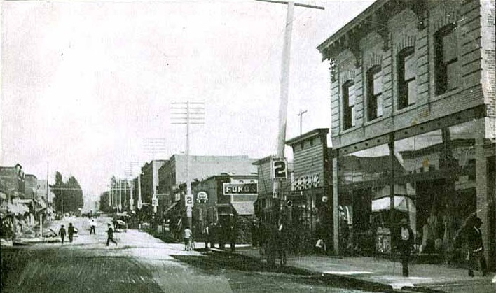
Coeur d’Alene itself swelled explosively. In 1900, the population hovered around 500 (post-fort closure in 1898-1900). The timber influx, combined with rail and steamboat networks, drew workers, families, merchants, and professionals. By 1910, the city boasted over 8,000 residents—a 16-fold increase in a decade—making it one of North Idaho’s fastest-growing communities. Infrastructure followed: six large lumber mills operated in or near the city (including Rutledge’s massive facility on the lake’s north shore), four banks financed expansion, five hotels accommodated transients, nine churches served diverse populations, and multiple railroads (Northern Pacific branches, electric interurban lines from Spokane) connected the town to markets. The waterfront buzzed with docks, warehouses, and steamboat traffic, while new streets filled with Victorian and Craftsman homes, schools, and businesses.
This rapid growth necessitated formal governance. Coeur d’Alene had incorporated as a town on August 22, 1887, but the timber-driven boom outpaced that structure. On September 4, 1906, voters approved incorporation as a full city under Idaho law, granting broader powers for taxation, utilities, streets, and ordinances to manage the influx. The charter reflected a maturing community: provisions for mayor-council government, police, fire protection, and public works. Just two years later, in 1908, residents voted to relocate Kootenai County’s seat from Rathdrum (the original 1884 location) to Coeur d’Alene. The move recognized the city’s economic dominance, central location, and superior rail/steamboat access. The county courthouse shifted operations, solidifying Coeur d’Alene as the political and commercial heart of the county.
The timber era’s prosperity was intoxicating but short-lived. Overcutting, market fluctuations, the 1929 stock market crash, and the Great Depression halved production by the early 1930s, shuttering mills and idling workers. Many companies consolidated (e.g., Rutledge merged into Potlatch Forests Inc. in 1931), while others closed. The Rutledge mill site—once among the region’s most productive—later became the Coeur d’Alene Resort grounds in the 1980s. Yet the boom left an indelible mark: it built the modern city’s infrastructure, attracted diverse populations, and laid the foundation for its shift to tourism and recreation. The white pine forests, once seemingly inexhaustible, were largely logged out by mid-century, but their legacy endures in the community’s resilience and the enduring beauty of the surrounding landscape.
Great Depression, World War II, and Post-War Growth (1930s-1960s)
The Great Depression struck Coeur d’Alene with devastating force, abruptly halting the timber-fueled prosperity of the 1920s and plunging the community into economic hardship. The 1929 stock market crash triggered a collapse in national construction and housing demand, which directly impacted lumber markets. By the early 1930s, production in northern Idaho’s forests had been halved or more from peak levels; many mills shut down entirely or operated on severely reduced schedules, often running just one crew intermittently before laying off workers for extended periods. Unemployment soared as loggers, mill hands, and related workers—once the backbone of the local economy—found themselves idle. In Coeur d’Alene and surrounding areas, the closure or partial shutdown of major operations like the Edward Rutledge Timber Company mill and smaller outfits left families struggling, with many turning to relief programs or subsistence farming. The region’s timber-dependent economy mirrored broader national trends, where overproduction, depleted forests, and the Depression combined to end the era of unchecked logging booms. Relief efforts emerged locally, but the pain was widespread—businesses faltered, banks faced pressure, and the population growth of previous decades stalled or reversed temporarily.
Federal New Deal programs provided critical relief and infrastructure improvements that helped stabilize the area. The Civilian Conservation Corps (CCC) and Works Progress Administration (WPA) were particularly active in northern Idaho, employing young men and local workers on conservation, road-building, and public works projects. One notable local effort was the construction of Northwest Boulevard in 1937, a WPA-funded project that improved connectivity around the city and lake, creating jobs while enhancing access for future growth. Other CCC and WPA initiatives included park development, trail building, and forestry work that preserved remaining timberlands and built lasting public amenities. These programs not only put money in pockets but also laid groundwork for the region’s recreational future.
Education received a boost during this era as well. North Idaho College (originally Coeur d’Alene Junior College) was founded in 1933 as a private institution, with classes initially held in City Hall to offer affordable higher education amid economic hardship. It served as a lifeline for local youth unable to afford distant universities, providing two-year programs in liberal arts, vocational training, and teacher preparation. In 1939, following the state Junior College Act, it became a public entity under the name North Idaho Junior College, relocating to the former Fort Sherman site on the lake’s north shore—preserving historic buildings while expanding facilities. By the 1940s-1960s, it grew into a key community asset, evolving into today’s North Idaho College (name changed 1971) with broad programs supporting post-war workforce needs.
World War II delivered an unexpected economic revival. In early 1942, the U.S. Navy selected a 4,160-acre site at the south end of Lake Pend Oreille (near Athol, about 20-25 miles north of Coeur d’Alene) for Farragut Naval Training Station, named after Civil War Admiral David Farragut. Groundbreaking occurred April 22, 1942, and the first recruits arrived just months later in September. The massive construction effort—employing up to 22,000 civilian workers (paid a then-generous $1/hour)—built six self-contained camps with barracks, mess halls, drill fields, hospitals, chapels, theaters, and recreation facilities across the sprawling base. It consumed an astonishing 98 million board feet of lumber—reviving Idaho’s timber industry at a critical moment. Farragut became the second-largest naval training center in the world (after Great Lakes), training over 293,000 recruits and 25,000+ in service schools (e.g., cooks, radiomen, gunners) by its 1946 decommissioning. The base’s population peaked at over 55,000, briefly making it Idaho’s largest “city” and injecting huge payrolls, contracts, and demand into Coeur d’Alene and nearby communities. Local businesses boomed supplying food, services, and entertainment; families rented rooms; and the war effort provided steady work after Depression years.
Post-war growth shifted the economy toward recreation and services, building on pre-war roots. Steamboat excursions had entertained tourists since the early 1900s—offering scenic cruises on the “shadowy St. Joe” River and around the lake, with meals of fresh trout and wild game—but automobile access and highways in the 1920s-1930s had reduced reliance on boats. After WWII, returning veterans, the baby boom, and rising leisure time fueled a tourism resurgence. Coeur d’Alene marketed itself as the “Lucerne of America”—a scenic alpine lake destination with boating, fishing, camping, and resorts. The Diamond Cup Unlimited Hydroplane races, launched June 29, 1958, became a highlight. Part of the annual 4th of July Regatta, these high-speed events on Lake Coeur d’Alene drew massive crowds (up to 30,000+ spectators) and national attention, featuring legendary boats like Maverick (winners 1958-1959), Miss Thriftway/Century 21 (1961-1963), Miss Exide (1964-1965), Tahoe Miss (1966), and Miss Bardahl (1968). Drivers such as Bill Stead, Bill Muncey, and Norm Evans thrilled fans with speeds over 100 mph, though accidents and rowdy spectator behavior (parties, fights) marred some years. The races ran annually through 1968, when voter initiative banned them due to safety concerns, excessive costs, and unruly crowds—ending an era of “thunderboats” but cementing Coeur d’Alene’s reputation as a speedboat and water-sports hub.
By the 1960s, the city had transitioned: timber declined, but tourism, education (North Idaho College expansion), small businesses, and lake-oriented recreation sustained growth. Infrastructure from New Deal and wartime eras—roads, parks, and the former fort site—supported this shift, setting the stage for the modern resort era.
Modern Era: Tourism, Growth, and Challenges (1970s-Present)
The 1970s and 1980s marked a decisive pivot for Coeur d’Alene, as the city transitioned from its historical reliance on resource extraction—timber and mining—to a service-oriented economy centered on tourism and recreation. With declining lumber production after the mid-20th century and mining’s environmental legacy under scrutiny, local leaders and investors recognized the lake’s unparalleled natural beauty as the community’s greatest untapped asset. Early tourism had roots in steamboat excursions and scenic cruises dating to the early 1900s, but the era’s investments transformed Coeur d’Alene into a year-round destination.
A key catalyst was the 1982 opening of Wild Waters, a $2 million aquatic theme park that introduced family-friendly water slides and pools, signaling the shift toward leisure amenities. The landmark development came in spring 1986 with the grand opening of the Coeur d’Alene Resort, a $60 million (equivalent to roughly $172 million today) luxury complex on the lake’s north shore. Built by publisher and developer Duane Hagadone (who acquired the existing North Shore Motor Inn in 1983 and expanded it dramatically), the resort featured an 18-story Lake Tower with 338 rooms and suites, panoramic views, a full-service marina, spa, convention facilities, and upscale dining. Architect R.G. Nelson’s design integrated modern luxury with the lakeside setting, including a three-quarters-of-a-mile (3,300-foot) floating boardwalk encircling the marina—the world’s longest of its kind at the time. This boardwalk, completed in 1985 during renovations, became an instant icon, offering scenic strolls, shopping, and direct lake access. The resort’s 1991 addition of a championship golf course, designed by Scott Miller, elevated its prestige further. The signature 14th hole—the world’s only floating, movable island green—weighs about 2,300 tons (some sources note up to 5 million pounds including ballast) and adjusts position via underwater cables to vary yardage from 75 to 175 yards. Players reach it by mahogany shuttle boat, adding a luxurious, memorable element that has drawn celebrities and golfers worldwide, with divers retrieving thousands of errant balls annually.
Just two years later, in June 1988, Silverwood Theme Park opened about 20 miles north near Athol, founded by Gary Norton. Originally a passion project on former aerodrome land (Henley Aerodrome, acquired 1981), it debuted with a 1915 steam train (purchased outbidding Disney), carnival rides, a “Main Street” village with shops and eateries, pony rides, and an aviation museum. The first year drew around 110,000 visitors. Over decades, Norton expanded it into the Northwest’s largest theme and water park: adding roller coasters (e.g., Corkscrew from Knott’s Berry Farm in 1990), Boulder Beach Water Park (2003), live shows, seasonal events like Scarywood Halloween, and over 70 attractions across 413 acres. Attracting 750,000+ annually, Silverwood complements lake-based recreation, creating a regional tourism powerhouse.
These developments fueled explosive population growth. From the 1970s onward, Coeur d’Alene and Kootenai County benefited from in-migration, accelerating in the 1990s and beyond. The city grew from around 24,500 in 1990 to over 54,000 by 2020, with estimates reaching approximately 57,000 by 2024-2025. Kootenai County’s population nearly doubled in the same period, driven by newcomers from California, Washington, and other western states seeking lower cost of living, affordable housing, outdoor lifestyle, scenic beauty, and a more relaxed pace. Remote work trends post-2010s amplified this, as professionals relocated while retaining higher-paying jobs. Tourism became the dominant economic driver, supporting hospitality, retail, healthcare, and services, with the Coeur d’Alene Tribe’s enterprises (casino, golf, agriculture) contributing significantly to regional vitality.
Environmental challenges from historic mining persisted but saw major progress. The Bunker Hill Mining & Metallurgical Complex Superfund Site (listed 1983) addressed legacy contamination in the Coeur d’Alene Basin. Ongoing remediation—dredging rivers, soil replacement, habitat restoration, and water treatment—has continued through the 2000s-2020s, with substantial settlements funding billions in efforts. The Coeur d’Alene Tribe has played a key role, asserting jurisdiction over portions of the lake and advocating for cleanup to protect traditional lands and water quality.
Recent decades have brought vibrant community events and attractions. Tubbs Hill, a 165-acre forested peninsula with trails, beaches, and panoramic views, remains a beloved free-access spot for hiking and picnicking. McEuen Park, renovated in 2014, transformed into a flagship urban green space with playgrounds, splash pad, sports courts, amphitheater, dog park, and lakefront paths—hosting concerts, festivals, and family gatherings. Ironman races have become signature events: the full IRONMAN Coeur d’Alene (discontinued after 2018) and ongoing IRONMAN 70.3 Coeur d’Alene (half-distance triathlon) draw thousands of athletes and spectators annually, with swims in the lake, hilly bike routes, and runs through historic neighborhoods to a downtown finish line. These events, plus seasonal festivals, farmers markets, and outdoor pursuits (boating, skiing at nearby Silver Mountain, bald eagle viewing), underscore the city’s appeal as an active, scenic lifestyle destination.
Today, Coeur d’Alene thrives as a tourism and quality-of-life hub, blending natural splendor with modern amenities. Its growth reflects adaptation—from resource extraction to recreation—while preserving the lake’s central role in community identity and economy.